For much more on
every aspect of life along the Mississippi River, visit
www.greatriver.com
... The Mississippi River Home Page. Scroll down to see the REAL TIME FLOOD
WATCH MAP.
Update: 5/3/11 - Missouri Levee
blown to relieve Cairo, Illinois, levees.
The Corps
of Engineers has established a number of flood "relief valves" all along the
Lower Mississippi River. These are basically secondary impoundment areas. When
the river is threatening a town, the levee can be deliberately destroyed to
allow the river to flood a controlled agricultural area. At one time the towns
were economically more valuable than the agricultural land. That balance has
changed to some extent and the concept is now being debated.
Officials in Louisiana and Mississippi are warning that
the river could bring a surge of water unseen since the Great
Mississippi
Flood of 1927.
George Sills, a former Army Corps engineer and levee
expert in Vicksburg, Mississippi, said the volume of water
moving down the river would test the levee system
south of Memphis into Louisiana.
"It's been a long time since we've seen a major flood down the Mississippi
River," Sills said. "This is the highest river in
Vicksburg,
Mississippi, since 1927. There will be water coming by here that most people
have never seen in their
lifetime."
Read more about the Missouri levee break: http://www.foxnews.com/us/2011/05/03/army-corps-breaks-southeast-missouri-levee/#ixzz1LI2UzwE7
2/2011
Mississippi River Real Time Flood Watch ... Moderate to severe flooding is
always a possibility in years when the snowpack is heavy.
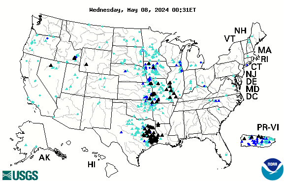
Below is a USGS map that provides REAL
TIME info on which Rivers in
the US are cresting. The map is accurate every day and is always posted on
our
RAMBLIN' ON
Blog. Black Triangles indicate flood stage. Looking to compare stats with
the Flood of 1993? CLICK
HERE.
Tags: USGS
Flood Map
Black Triangles on map indicate rivers
at flood stage at any given time.
Read on for:
Spring
Floods in '08
Stats from August '07
The Great Flood of 1993
Remembering Valmeyer, Illinois
Disaster in the Bluffs
2008
June FLOOD REPORTS:
6/29/08... Click to see our
Blog for Mississippi River crests from Burlington to St. Louis as
Missouri rains cause the Mississippi to swell.

Persistent heavy rains are
wreaking havoc along rivers in the Midwest. August 07 was considered a 1000 year
flood. The damage in early the weekend of June 7th (2008) is even greater! Rains
of 7-9 inches from the Iowa border to Wisconsin Dells, Wisconsin, have resulted
in "floods of record" through south western Wisconsin, northeastern Iowa
and southeastern Minnesota.
ON JUNE 12, Grant County received an additional
4" of rain... and the Grant River rose another 8 feet in two hours!
The Army Corps of Engineers has alerted commercial barges that they expect to
close a 256 mile section of the river, from Fulton, Illinois to Clarksville,
Missouri to boat traffic beginning as early as THURSDAY as flooded tributaries
continue to pour waters into the Mississippi. The closure could last two
weeks... if the rain ends!

Above
and left are two photos of the Root River in Minnesota... this one taken about
June 1, '08 and the one above take about June 8, '08.
Photos courtesy of Alan Stankevitz, La Crescent, Minnesota
Below, a new USGS real time map of cresting rivers...
and Frequent Updates on the
Mississippi River Blog.
Spring Floods in 2008 fairly typical when
rain and snowmelt are heavy in the north.
What was different about flooding in Spring of '08 and the
floods of June-August 1993? DURATION is the key. The flooding we see occurring
on the Lower River in '08 is typical of life on the river... the river comes
up and the river goes down. If it rains in the north, when the snow melts, the south
feels the effects as the Missouri, the Upper Mississippi, and the Ohio
converge. The difference is that in 1993, it rained for 58 days straight
throughout the Midwest. The river... simply... never... went... down!
Monday, April 7th, 2008
I
recently ran across a number of stats presented by area scientists regarding
the massive rains along the Upper Mississippi River last August. These rains
produced unprecedented landslides in bluff country that resulted in seven
deaths and several homes on both sides of the river sliding down onto the
roads.
For more detailed stories, stats, photos, and reports from the
August 07 flooding and landslides, see
http://www.greatriver.com/natural/disaster/August07.htm
Official FLOOD STATS
15.1 inches of rain fell in Hokah, Minn., over a 24 hour period on August
19. The previous high was 10.84 inches set in 1972.
The Root River crested at 18 feet in Houston, Minn. When compared with
previous flooding events, the August ‘07 floods had up to 5 times more
rainfall.
Scientists report that the flood was so rare, the probability of its
existence was once in 500 years, perhaps even once in 1,000 years. The
storm’s wrath was comparable to a Category 5 hurricane.
Interestingly enough, the invertebrate count in large streams fell from
about 4,000 per square meter to just 1000 after the flood. A specific
amphipod, a staple of trout diets, dropped from about 250 per square meter
to less than 10.
23.6 inches fell during the month of August, 9.5 inches shy of the
average ANNUAL precipitation.
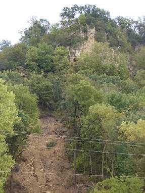
For more on the dangers posed by landslides on the 600 ft high bluffs
along the Minnesota and Wisconsin border see our feature from Fountain City,
Wis., When Bluffs
Throw Boulders. On April 5, 1901 a single boulder fell from
the bluff face to smash a home and kill its occupant. Some 85 years later it
happened again… in the same spot. This time, the Rock was left in place and
is open to the public for viewing at the Rock in the House
attraction on Hwy 35.
Statistics, Stories, and Chronology from the Great Mississippi River
Flood of 1993
©
1996 Heritage Press/Great River Publishing. All rights reserved
Click
here, "disasters"
for more stories related to disasters related to Mississippi River natural
history
1993 Mississippi Flood CHRONOLOGY
March
10
The
National Weather Service predicts below normal precipitation for the summer:
“but above average rainfall could mean flooding, given soil saturation, spring
snow depths, and normal spring rains.”
June 10
The
first 8” rainstorms begin in
Dakotas, Wisconsin and
Minnesota
June
20
The
first dam bursts, submerging 100 homes to their rooftops on the Black River in
Western Wisconsin. The upper 200 miles of the Mississippi River are closed to
river traffic. Locks and Dams are not operating.
July
5
The
bridge at Keokuk closes.
July 10
The
bridge closes at Fort Madison,
Iowa, which has experienced rain for 54 of 58 days. 830
miles of Mississippi
River are closed to boat traffic between Cairo, Illinois and St. Paul,
Minnesota. Over 100 rivers feeding into the Mississippi River flood by July
14. Unprecedented high-water on the Missouri River, Des Moines River,
Illinois, Iowa, Skunk, Rock and Raccoon rivers (all tributaries of the
Mississippi River) promote the massive flooding of the
Mississippi River.
July 16
The last
Quincy, Illinois, bridge is closed, leaving no bridge between
Alton,
Illinois
and Burlington, Iowa. The Mississippi River is flooded to seven miles inland.
July
24
The
Mississippi River at Quincy crests at a record 32 feet.
August
2
The
Mississippi River crests at 49.7 feet in St. Louis, Missouri. Eleven times the
volume of Niagara Falls is flowing under Eads Bridge; enough to fill Busch
stadium every 65 seconds.
August
24
The
Mississippi River locks reopen to commercial river traffic.
August
30
The Des
Moines River floods again, after another 10 inches of rain falls. The
Mississippi River stays open.
Sandbags
and Stuff
(Statistics
collected from various regional newspaper sources.)
-
Estimated that two truckloads of sand (a little less than fifty tons) will
fill 4000 sandbags.
- More
than 26.5 million sandbags were used in towns along the
Mississippi River
during the Flood of 1993
-
Approximately 927 million pounds of sand was used to fill those sandbags
-
Homeowners had to fill their own sandbags
- In
all, 150 primary and secondary levees failed during the summer.
- 12
billion dollars in damages
- 48
deaths
- nine
states involved
- 1
inch of water on an acre of land equals 27,143 gallons.
Rain, too much rain, was the root of the problems. By July 15th,
every area had a least twice its normal rainfall, some had six times as
much. A high pressure system in the Southeast forced Gulf air to move north,
hitting cool Northwest air. It stalled right there, continuing to produce
massive rainfalls. It was the wettest June and July since 1895.
There were twelve major storms with rainfalls of 6 to 12 inches, 16,000 square
miles of farmland were under water. Seventeen million acres were inundated
during the flood.
Flood Projections for 1996: April
2, 1996
The
National Weather Service issued a revised report on the potential for spring
flooding on the Mississippi River. The report is considered to be a “worst
case scenario” and projects that if normal precipitation falls and average
temperatures prevail in the coming weeks, the Mississippi River could crest in
La Crosse, Wisconsin at 15.5 feet…. 3.5 feet above the Mississippi River’s
flood stage. If little precipitation falls in coming weeks, the crest could be
lower, at 13 feet. Heavy snow that fell over most of Minnesota and Wisconsin
last week motivated the revised report. In addition, cold temperatures have
delayed the snow melt, increasing the chances for a rapid melt in the north
during April.
INSIGHT FEATURE:
Remembering Valmeyer, Illinois and the 1993
Mississippi River Flood.
You may also be interested
in other disasters related to Mississippi River
natural history...