Landslides, Floods, and Winds make August 2007 a Devastating Weather Month for Wisconsin and Minnesota along the Upper Mississippi River!
© Pat Middleton... To see picture captions, hold your cursor over photos.
August 20, 2007
“Mom, you missed the HUUUgest Storm!”
“Mom, you have to hear what’s happening. I’ll read it right from the newspaper!”These two phone calls from my daughter during our recent Alaska cruise brought news that had not yet appeared on the Weather Channel… A thousand-year rainfall of 11-15” over two days had left the Coulee country from Winona, Minnesota, to
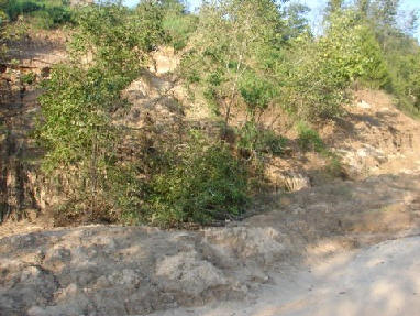
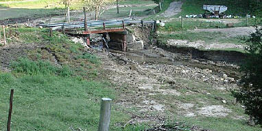
Genoa and Viroqua, Wisconsin, virtually impassable. Mudslides, a few carrying homes with them, littered major and minor roads. Bridges were awash, as creeks that normally carried a 20-ft creek flooded to 100 ft, or as in our case, flooded entire valleys. Household water wells filled with mud and bacteria. Waterfalls gushing over the rocky bluff faces turned normally stable hillsides into a gelatin consistency that began an unstoppable flow down the 600 ft. high bluffs. Canyons formed where there were none on August 18.
“Pat, there were not even scars in the places where vast, denuded ravines now show on the bluff sides,” a friend told me over the phone. “You won’t recognize the bluffs. Such devastation!”
My friend was able to dig many of his beehives out of the mud, but he lost many more. He couldn’t believe that many of the hives he dug out still had bees alive in them.
August 22, 2007
60 and 70-mile an hour winds and rain, more rain, blow through Vernon County, adding insult to injury as counties began to fathom the extent of damage to roads, bridges, and homes.
September 7, 2007
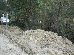
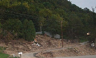
County road workers have cleared most roads and have started the process of moving mud out of and reshaping the deep drainage ditches that normally suffice to redirect rainwater and an occasional boulder. But mudslides still litter the roadsides and valley floors. Folks are still out, clearing, hauling, drying, filling out forms, sanitizing wells, basements. What is so amazing, even today, is the vast scope of the damage. Not just here or there, but entire neighborhoods whose residents do not qualify for flood damage or earthquake, though their homes were moved off foundations. Or the bluffside collapsed in their yards.
Twenty-five dump truck loads of mud were removed from one yard in the Goose Island area. It took nearly a week for road crews to clear Hwy 35 from Goose Island to Stoddard of mud and debris.
Why it Happened, or Bluff Geology 101
The bluffs of the “Driftless” region that stretches along the Mississippi River are formed of limestone bedrock covered by an ancient mix of clay and river silt. Under most conditions this is provides a solid base for home building, though most counties restrict building to a slope of 20-30%. Homes that are built on “benches” may have much steeper areas above them (or below). Between 1998 and 2006, 205 homes and 10 condominiums were built in La Crosse County on slopes with between 20% and 30% slopes.
Historically heavy rain during the night of August 19, 2007, meant that water drained from the tops of the bluff to flow into the valleys. Water flowing over the rock faces probably fell like fabulous waterfalls (though I haven’t run across anyone who can claim to have seen it). This completely saturated the clay and silt which cover the bluffs.
According to a La Crosse Tribune story, as water particles fill the space between silt particles the silt and clay first
become “plastic” and then “viscous.” When “plastic” it will move when pressure is applied to it (such as the weight of a home). When “viscous” it begins to flow under its own weight… like a glacier, only much more quickly. This flow is what caused the collapse that is so visible in the bare canyons, and the mud and rubble along the base of the bluffs throughout the coulee region.
The soils may have been more vulnerable because the area was so dry, and the water fall so far beyond the historic record. The fact that residents remove the thick canopy of deep rooted trees and brush to plant grass may also have made the bluff sides more vulnerable, according to La Crosse County.
Aftermath?
Certainly many counties will be reconsidering restrictions on developing bluff side slopes. Onalaska currently restricts building on slopes of more than 20%, Holmen restricts building on slopes over 12%, La Crosse 30%, town of Bergen restricts development at 20% but does allow building on “benches.” Winona currently restricts building on slopes greater than 15%.
Many researchers point to increasingly severe droughts, rain and heat as the by-product of global warming. So can we expect more such rains? The experts do think so.
A (unofficial) SUMMARY of damages caused by the August rains
- 7 people died in flooding caused by rainfall
- Flash flooding along Hwy 35 near Goose Island washed out 400 feet of Burlington Northern railroad track, derailing 5 cars. Nearly 50 rail cars (150 dump trucks) of rip-rap were required to fill the gap. The company expects that another 150 carloads of ballast or fill would be required to repair the tracks.
- Vernon County Sheriff's office dispatchers fielded 3,800 phone calls over 16 hours during the worst of the flooding.
- 3 Minnesota counties along the Mississippi River (Winona, Houston, and Wabasha) were declared Federal Disaster areas. Bridges, roads and more than 4,200 homes in Minnesota were damaged, 338 with major damage. Villages of Houston and Rushford were inaccessible because of flooding along the Root River. Many other Houston County residents were evacuated.
- 3 Wisconsin counties were also declared Federal Disaster areas: La Crosse, Vernon, and Crawford. Residents were evacuated from south La Crosse and Goose Island areas.
- Two homes slide onto Hwy 35 south of La Crosse. Residents are evacuated below two flood control dams in Vernon County. Water in the streets of La Crosse reached waist high in some areas. Gays Mills in Crawford County was evacuated after the Kickapoo River flooded, leaving over $14 million dollars in damages.
- Thousands of homes are damaged or destroyed, 300 of them in the City of La Crosse. Many more will be condemned.
- La Crosse County received up to 10.95 inches, Vernon County received from 11.75 inches in Stoddard to 9.23 inches in the Viroqua area. Gays Mills flooded severely with 7.41 inches.
- For all the rain, flooding on the Mississippi River was never a major concern.
- Throughout the Coulee region homes were lost, residents were rescued from cars and rooftops. Emergency personnel, including volunteer fire departments slogged through deep water to warn and rescue residents. Red Cross shelters provided food and shelter. Local fundraising collected over $400,000 in one day for those who lost property in the storm.
- The summer of 2007 is now the wettest summer on the historical record. While Gov. Doyle declared 52 counties in Wisconsin to be under a drought emergency on August 14, by the end of the month over 20” had fallen in parts of Western Wisconsin.

 Click here
to Recommend www.greatriver.com to a Friend!
Click here
to Recommend www.greatriver.com to a Friend!
Click below for excellent Photos posted immediately after devastating floods and landslides in Minnesota and Wisconsin
Brownsville, MN | Hokah, MN | Goodview & Winona, MN | Bad Axe River | Sidie Hollow | Winona, MN City | Mount Sterling | ChaseburgWhen Boulders Roll
The Floods of 1993 and 1996Return to the Mississippi River Home Page at www.greatriver.com