 My husband woke me up early today to look at Eagles on the website, www.iwishicouldfly.com by Alan Stankevitz of La Crescent, Minnesota. Wonderful photography of not just eagles, but a long list of bird photos… including a very clear shot of a red-winged blackbird, wings folded, simply riding on the back of a redtailed hawk. His photos always include something a little unexpected! Alan is passionate about his art, but he is also generous about sharing tips on equipment and offers a journal with highlights from his bird shoots.
Landing a giant catfish, Turtle Man, and SHANTY BOATS!
OK, folks, I have just found the best You Tube pieces on fishing for river cats (including a GIANT) and catching snapping turtles!! Here they are! First watch the TURTLE MAN catching snappers by hand. Play it through and then you have a choice of several more at the bottom. Try the GIANT CATFISH in film #6. Whew! Finally, if you have a little time, join the “Moron Brothers” in the SHANTY BOAT! A little pickin’ and grinnin’ and fishing! Then check out our weekly fishing updates from Pool 8. Or read a first hand story of a young man’s shanty boat adventure on the Mississippi River in the 1930s.
Real Time Flood Watch
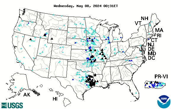
Below is the USGS map that provides REAL TIME info on which Rivers in the US are cresting. The map below is accurate every day. Black Triangles indicate flood stage. Looking to compare stats with the Flood of 1993? CLICK HERE.
Official Flood Stats from August 2007 Rains in Minn/Wis
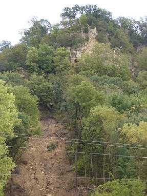 I recently ran across a number of stats presented by area scientists regarding the massive rains along the Upper Mississippi River last August. These rains produced unprecedented landslides in bluff country that resulted in seven deaths and several homes on both sides of the river sliding down onto the roads.
For more detailed stories, stats, photos, and reports from the August 07 flooding and landslides, see http://www.greatriver.com/natural/disaster/August07.htm
Official FLOOD STATS
15.1 inches of rain fell in Hokah, Minn., over a 24 hour period on August 19. The previous high was 10.84 inches set in 1972.
The Root River crested at 18 feet in Houston, Minn. When compared with previous flooding events, the August ’07 floods had up to 5 times more rainfall.
Scientists report that the flood was so rare, the probability of its existence was once in 500 years, perhaps even once in 1,000 years. The storm’s wrath was comparable to a Category 5 hurricane.
Interestingly enough, the invertebrate count in large streams fell from about 4,000 per square meter to just 1000 after the flood. A specific amphipod, a staple of trout diets, dropped from about 250 per square meter to less than 10.
23.6 inches fell during the month of August, 9.5 inches shy of the average ANNUAL precipitation.
For more on the dangers posed by landslides on the 600 ft high bluffs along the Minnesota and Wisconsin border see our feature from Fountain City, Wis., When Bluffs Throw Boulders. On April 5, 1901 a single boulder fell from the bluff face to smash a home and kill its occupant. Some 85 years later it happened again… in the same spot. This time, the Rock was left in place and is open to the public for viewing at the Rock in the House attraction on Hwy 35.
GEOLOGY 101… WHY Land Slides Happen along the Mississippi River Bluffs
 The bluffs of the “Driftless” region that stretches along the Mississippi River are formed of limestone bedrock covered by an ancient mix of clay and river silt. Under most conditions this is provides a solid base for home building, though most counties restrict building to a slope of 20-30%. Homes that are built on “benches” may have much steeper areas above them (or below). Between 1998 and 2006, 205 homes and 10 condominiums were built in La Crosse County on slopes with between 20% and 30% slopes.
Historically heavy rain during the night of August 19, 2007, meant that water drained from the tops of the bluff to flow into the valleys. Water flowing over the rock faces probably fell like fabulous waterfalls (though I haven’t run across anyone who can claim to have seen it). This completely saturated the clay and silt which cover the bluffs.
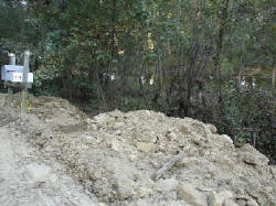
According to a La Crosse Tribune story, as water particles fill the space between silt particles the silt and clay firstbecome “plastic” and then “viscous.” When “plastic” it will move when pressure is applied to it (such as the weight of a home). When “viscous” it begins to flow under its own weight… like a glacier, only much more quickly. This flow is what caused the collapse that is so visible in the bare canyons, and the mud and rubble along the base of the bluffs throughout the coulee region.
The soils may have been more vulnerable because the area was so dry, and the water fall so far beyond the historic record. The fact that residents remove the thick canopy of deep rooted trees and brush to plant grass may also have made the bluff sides more vulnerable, according to La Crosse County.
Aftermath?
Certainly many counties will be reconsidering restrictions on developing bluff side slopes. Onalaska currently restricts building on slopes of more than 20%, Holmen restricts building on slopes over 12%, La Crosse 30%, town of Bergen restricts development at 20% but does allow building on “benches.” Winona currently restricts building on slopes greater than 15%.
Many researchers point to increasingly severe droughts, rain and heat as the by-product of global warming. So can we expect more such rains? The experts do think so.
More!
Chronology of the Rains in August 2007
When Boulders Roll … Landslides on the River
Return to the Mississippi River Home Page at www.greatriver.com
Weekly Fishing Reports
NO FOOLIN’… Fish are biting as the ice clears out! But you gotta dress warm.Click link to catch our weekly
Fishing Reports from the Genoa (Wis) Fishing Barge.
Pelicans and Wabasha Eagle Counts
March 23, 08 and the American White Pelicans are back in Pool 8. Read our feature story on the return of the AMERICAN WHITE PELICANS to the Upper Mississippi River.
Also got a count for the March 08 eagle count from Wabasha. Note that Golden Eagles are included in the count! I, too, have seen Goldens, but they have been so few and far between we haven’t even mentioned them. I guess the word is now out! The bulletin board at www.greatriver.com/pbb/ shows a huge increase in eagle counts for Iowa.Eagles have been especially abundant on Pool 8 for the past two weeks as “winter” eagles wait for the waters further north to open and “summer” eagles start arriving for nesting. I counted 9 adults in two trees near open water on March 23.
Eagle Sightings Winter 2007-2008
The NEC’s 2008 Annual Golden Eagle Survey Count was on Jan. 19, 2008. The 2007 count was 41 golden eagles for the day and 51 for the week, up from 2006’s 23 for the day and 29 for the week.
2008 results are being tallied now!Eagles Counted On or around March 14:
- Red Wing (Colville Park) 15
- Reads Landing 63
- Wabasha 24
- Alma 15
- Buffalo City 16
- Lock and Dam 5A 5
Some eagles are flying, however most are roosting.
Save the Delta Queen – An American Treasure
Ways to help. | Contact talk radio and Presidential candidates
My Goodness, I am a fan of the Delta Queen and all the cruising steamboats. Enjoy the U-tube video then have a look at the Blog entry below. There’s lots more to the tug of war over the DQ than is commonly known.
The Delta Queen is equipped with the latest in modern fire monitoring devices and a powerful sprinkler system, and includes 3 onboard crew dedicated to safety monitoring on a 24 hour basis. The steamboat has had an 82 year spotless record of safety on the river, and is popular with tourists who want a one-of-a-kind experience. So why is so-called fire safety being noted to force it out of operation? Read the full story.
Spring Flood Reports ’08
While another 6-14 inches of snow that fell in Wisconsin on Good Friday is likely to be short-lived, melting snowpacks in the north and massive rains (up to a foot in many places) in lower Midwestern states has precipitated a flurry of Flood Reports to www.greatriver.com Here’s what I heard overnight:
Floodwaters at Poplar Bluff, Missouri (Photo by James Ramsey)
The high-water crest is likely to be April 8 in Baton Rouge. Water levels are not expected to breach any levees.
A flood warning is currently in effect along the Mississippi River for parts of Illinois, Missouri and Kentucky. The Mississippi River at Cape Girardeau is still expected to crest at 44.5 feet Sunday despite levels being lower than expected north of the region. Flood stage is 32 feet. In Cape Girardeau, crews are racing to close the big steel flood gates that safeguard the town from the rising river.
Widespread flooding in Arkansas has washed out some highways and led to evacuations in some areas, said a spokesman for the Arkansas Department of Emergency Management. Heavy winter snow combined with recent rain indicates parts of Wisconsin and Illinois should see minor to moderate flooding, with as much as a 20 to 30 percent chance of major flooding on some rivers in southern Wisconsin and northern Illinois.
Some residents of southern Illinois had to evacuate. In Marion, Illinois, firefighters used their own fishing boats to rescue residents. At Paducah, Ky., the flooding on the Ohio River is expected to peak at 47.0 feet by Wednesday morning. The river’s flood stage is 39.0 feet. From historical floods, officials know that property damage begins along the river’s banks when the water rises to 47.0 feet.
A record flood is forecast for the Meramec River near Eureka, Mo., which is located south of St. Louis. By Saturday afternoon, the river is expected to slightly rise past the current record flood level of 42.9 feet from Dec. 6, 1982.
While the recent heavy rain bypassed the lower Mississippi River, residents along its banks are being warned that prolonged flooding will ensue. As water from its tributaries continues to flow downstream, the river will continue to rise.
The Mississippi River at Natchez, Miss., is forecast to exceed its flood stage of 48.0 feet by Tuesday. The river is expected to rise at least 5 more feet by Sunday, April 6. The National Weather Service is reminding people to be aware and be prepared for flooding in their communities. There is no expectation that current flooding will be more than a passing crest… unlike 1993 when the high water settled in and the entire river was closed for two months.As for travel in these states, I know from our flood experience in Wisconsin that nothing devastates tourism like these flood reports. Yet pictures like the one above are generally tiny pockets in the overall travel picture. Call ahead to double-check. Be aware of your surroundings. NEVER drive onto water covered roadways. But chances are there is no reason at all to cancel travel plans unless you planned to be right in the path of a flood-cresting river.
Last word on Snow Country
Well, now that our Sandhill Cranes, bluebirds, red-winged blackbirds, Kestrel, and Canada geese are back in the valley, my observations on snow country must suddenly give way to spring. But not before I share some pictures of one of my favorite “collector” items…Every so rarely a genetic WHITE PHASE appears in animals that are normally not white except as albinos. But the two pictures shown here are not albinos, but a “white phase” black bear and a “white phase” sparrow.
I’ve also heard of river islands with concentrations of “white phase” muskrats, and “white phase deer”, and of course, white phase buffalo. I’d love it if you could share photos of your “white phase” creatures for use in a future feature article.
Any way, the short story is that these “white phase” or “Spirit” creatures are expressing recessive genes that helped to protect the species during the ice ages. In Wisconsin, a northern game warden told me that in his life time, he’s only heard of two white phase bear cubs… both in the vicinity of Superior, Wisconsin. Hmmm… makes sense. The same game warden has seen only one white phase sparrow… nearly 40 years ago. I wonder if the white phases of various birds of prey are also expressing recessive genes related to living along the edge of glaciers?
Above is a very rare “white” black bear cub. Also known as Kermode or “spirit” bears. Normally found only in areas where the recessive white gene was encouraged by small populations cut off from the larger populations, probably by glacier formations. The white gene would have been advantageous to bears living on the edge of the snowfields.
Ice and Snow
DEER PATHS
While walking through deep forest last weekend with a game warden … snow nearly 3 foot deep and no snowshoes… I learned a lovely “Indian trick”… to walk directly on the deer paths visible in the snow. As deer walk their paths through the winter, the snow is compacted. So while the 3-foot deep snow off the paths had us floundering, walking directly on the deer paths provided solid, easy footing.MEASURING SPRING ICE DEPTHS
River ice is to be measured for the next week to develop a forecast for when the first commercial barges might be able to come north through Lake Pepin. According to KTTC, Rochester, MN, the ice is measured at 25 coordinates between Wabasha and Frontenac, Minnesota.The tows generally begin pushing up river in mid-March, but ice depths must drop below 12 inches. Currently, the ice is still 17 inches thick. If necessary, barges are lined up in SINGLE FILE to get through the ice. It’s called “mule training.” One new barge dispatcher remarked, “I didn’t even know we still used mules!”
For some great photos and observations from one of those towboat pilots who had to push through Lake Pepin every year, I recommend ONE MAN and the MIGHTY MISSISSIPPI by Capt. Norman Hillman. Look for the “Riverbooks” dock on the home page at www.greatriver.com
MORE SNOW! and dealing with the MELTOFF
Finally we are expecting more snow today, hopefully without any plummeting temperatures. Snow was melting yesterday, so talk of spring floods is starting to perculate. Thus far, official suggestions are that flooding will not be a big issue along the Upper Mississippi. But we haven’t seen this much snow in many years, either. My guess is that further down river flooding will be more of an issue. So we will be posting updates as we get them.FEEDBACK
Have a great day! Click on the word COMMENT (or “No Comment” perhaps) below each entry to contribute YOUR comment. Spam control on the BLOG is excellent, so this may take the place of our Bulletin Boards. I love the feedback from our river buff readers.

 NO FOOLIN’… Fish are biting as the ice clears out! But you gotta dress warm.Click link to catch our weekly

 Well, now that our Sandhill Cranes, bluebirds, red-winged blackbirds, Kestrel, and Canada geese are back in the valley, my observations on snow country must suddenly give way to spring. But not before I share some pictures of one of my favorite “collector” items…Every so rarely a genetic WHITE PHASE appears in animals that are normally not white except as albinos. But the two pictures shown here are not albinos, but a “white phase” black bear and a “white phase” sparrow.
