Thank you to my favorite photographer for his first Tundra Swan alert:
“After a long and arduous wait the Tundra Swans have finally arrived in number on Pool 8 of the Mississippi River. (Usually I am busy photographing along the MS during the whole month of November, but not this year.)
Enter Swans in the Search Box at the upper right to pull up historical arrival dates back to 2008! Interested in Eagles? Enter Eagles in Search Box… or anything else you are curious about!!
Reports of perhaps 1000 Swans resting off the Brownsville, MN, overlook. Saw about a dozen south of Goose Island at the overlook. Large numbers of Pelicans as well! Naturalists were available with spotting scopes. Thanks, folks!
A few days ago, my Tundra Swan search on the Mississippi River south of La Crosse came up empty. Today, small groups are out there south of Goose Island and most likely Brownsville, MN, as well.
If you spot Swans, let us know!!
For those who might be interested in a guided Swan watch, the La Crosse Audubon Society is offering a Swan watch on Sunday Nov 13 at noon. Here is the full story.
We will be holding our annual Tundra Swan field trip on Sunday November 13 at Noon. We will meet at the Kwik Trip in La Crescent. It is the one at the only stop lights in La Crescent on the corner of Hwy 14 and 16. The address is 319 south 3rd. We will be parking on 3rd street behind the Kwik trip and be leaving from there and making a few stops before the final destination being the Brownsville overlook. We normally go about 2 hours, but as always your free to come and go as you please.
Today and the week to follow is a great time to explore the coulees, streams and river valleys, bluffs and trails of the Driftless Region of Western Wisconsin, NW Illinois, SE Minnesota and and NE Iowa!
Pelicans are mobbing up into great clusters of pristine white on the Mississippi River. Bald Eagles are abundant… we saw several pairs just hanging out in nests, enjoying the day as much as we were! Can’t say I’ve seen Tundra Swans as yet…which is fine with me as they remind us a frozen river is not far behind!!
The river has finally dropped a bit, so fishing has picked up. Fishing Barges and boat landings we saw were busy.
The Fishing report from Clements Fishing Barge: “November 3rd: Fishing has been pretty good for walleye and sauger. White bass are done and the perch scarce. Most fish are coming in on minnows or hair jigs. Guys are still using 1 oz jigs, water is still higher than normal, but fish are in.”
Welcome! IT’S A GREAT RIVER! and a GREAT GIFT… for your favorite Mississippi or Missouri River Buff, Retiree, or Armchair Traveler! Order Securely Online TODAY!
Please visit our new Great River Shopping Cart for Artisan maps, Historic Maps, and Custom Designed Maps by Map Artist, Lisa Middleton. Click Image
below and enter key word in SEARCH BOX. Several Hundred maps!!
We believe we have the most extensive collection of eye-popping interpretive river cards available!!
Please call 888-255-7726!
Books, Books!
Click Image below to see Mississippi River Guides!
“We just traveled 5829 miles along the Mississippi River; from Baton Rouge, LA to Lake Itasca, MN up thwest side of the river and back down to Interstate 80 on the east side. Your DISCOVER! guidebooks are wonderful. We are going back next year to go the rest of the way to the end in the Gulf of Mexico. Thanks!” ~ Faith
Click Image below to see ALL our Steamboat and Railroad Books!
To order any of our products, call Great River Publishing toll-free at 888-255-7726 or order securely online at www.greatriver.com/order.htm
You may also order any of our books or maps by
mailing your personal check or money order to
Great River Publishing
W987 Cedar Valley Road
Stoddard, WI 54658
Please include $7 shipping with your order.
Story is adapted by Pat Middleton, www.greatriver.com, from an article by Bob Mullen, for The Paddlewheel newsletter published by the Golden Eagle River Museum, St. Louis, Missouri
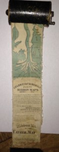
(Left) Authentic Historic Ribbon map with Winder, sized for use on the boat.
Imagine a map of the Mississippi River that shows all of the cities and towns along the river and all the landings where a steamboat might stop.
Make the map about three inches wide and in one continuous strip showing the entire river from the Gulf of Mexico to its source at Lake Itasca, Minnesota. If you imagined correctly, you would have a map that is about eleven feet in length, like a long streamer or ribbon. Now roll up the map to a couple of inches in diameter and put into a wooden cylindrical container that can easily fit into your pocket!
For Jack, who wants to know more about all the tributaries of the Mississippi River: how many there are, their names, and how long they are!
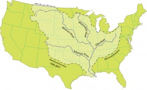
There are some 250 tributaries of the Mississippi which drain a total area of more than 1,247,000 square miles–one third of the nation’s landmass–extending from the Allegheny Mountains in the east to the Rocky Mountains in the west!
Remember the Mississippi River Flood of 1993? It wasn’t just the Mississippi River flooding that wreaked havoc, it was that all those tributaries flooded as well! At one point, the volume of water flowing past St. Louis was eleven times the volume of Niagara Falls!!
We start here with quick facts on the Mississippi River and several navigable tributaries! Please follow links for a little more depth of historical interest and to see our collection of hand-painted maps!
The Mississippi River, from its source at Lake Itasca in Minnesota, to the Gulf of Mexico, is approximately 2,348 miles long. The combined reach of the Missouri-Mississippi Rivers is 3,741 miles–a length exceeded only by the Amazon and Nile rivers. The Mississippi River has shortened by several hundred miles since the days of Mark Twain. Even today it varies 30-50 miles each year.
The widest navigable part of the Mississippi is Lake Pepin, on the Upper Mississippi, where it is approximately 2 miles wide. The average current flows from 1.2 miles per hour nearer Lake Itasca, and about 3 mi per hour nearer New Orleans.
Our Mississippi River Ribbon Map has been a best-selling Gift for many years. Lisa now offers her own custom ribbon map designs of both the OHIO RIVER and the Missouri River. Please click on any map image for more info on the map or the tributary. Or PHONE 888-255-7726 to order any map. Mention you saw it on greatriver.com for a one time 10% discount! Click on map images for more info on the tributaries.
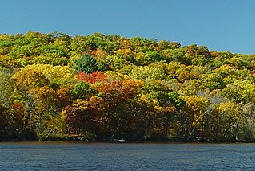
Mid-October seems to be the month when Fall Foliage really POPS along the Upper Mississippi River. You can follow its southward march with the contacts below. Weather is perfect, enjoy the drive!
Arkansas. 800-628-8725; www.1800natural.com (late October to early November)
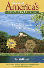
And don’t leave home without the indispensable guides to Mississippi River and Great River Road travel! Every volume of DISCOVER! America’s Great River Road is filled with a variety of fascinating Mississippi River fact and lore. Photos, maps, charts! All Volumes contain info on birding, wildlife viewing hotspots. Each highlights Geography, interpretive history and natural history attractions along the Great River Road.SAVE $10!!! Purchase ALL FOUR VOLUMES of Discover! America’s Great River Road… St. Paul, Minnesota, to Venice, Louisiana, individually signed by the author. Four guides for $62.
Recent landslides after rains of 9-11 inches have many of us reminiscing about past experiences of landslides, rockslides, and flooding along the Mississippi River. Below is my own memory from very similar flooding in 2007.
Enter FLOOD in the Search button to bring up an interactive map that shows flooding at any moment along America’s major waterways as well as stats and Chronologies from previous years..
August 20, 2007
“Mom, you missed the HUUUgest Storm!”
“Mom, you have to hear what’s happening. I’ll read it right from the newspaper!”
Let us celebrate with historic French maps! Click on the maps to read detailed histories from Great River Arts… Lisa Middleton, Map Artist.Pause the curser over the map image and a magnifying glass with allow you to study the maps!!
We will do a different century through this coming week! First, the 18th Century.
Les Etats Unis 1765 (approx)
Iowa/Wisconsin Territory
Les, Etats Unis, detail of Upper Mississippi River… “The Source of the River is Unknown..”
Ft Beauharnois near today’s Frontenac Minn
1731, De L’Isle’s CARTE DE LA LOUISIANE… With Lake Pepin Named on the Upper Mississippi River…. name requested by King Louis 14th!