Home �
Products
�
Antiqued Mississippi River Maps
Antiqued Hand Painted Mississippi River Maps
make great Gifts for your family River Buff
or Traveler!
"Thank
you, my father loved his map!" ~ New Orleans
"Your
Ivory map is beautiful!! He will love it! Thanks so much!"
~ Seattle
"I have
to ask you for two more maps... my wife wants them for the
living room and I'm not willing to give up mine in the den!"
~Illinois
The Les
Etats Unis is beautiful. Thanks for going the extra mile for
us!" ~ Washington, DC
"We received our map yesterday... it is fabulous!"
~Atlanta, Georgia
My Lt.
Ross map was wonderful. I framed it and display it next to an
antique Scottish map. The artist did a beautiful, beautiful
job! ~ Texas
I am
replacing a map my husband remembers as a child. It is so
meaningful to him. Thank you! - Louisiana
"We
loved our giant 1887 ribbon map! It's perfect for the 2-story foyer." Mpls, Mn
"Absolutely, we thought the hand-painted maps were fabulous.
They have terrific impact in our gallery windows!"
~Vintage Gallery, 429 Royal Street, French Quarter, New
Orleans
"I
visited this site one thousand times... I'm so excited to have
my 60" ribbon map!" ~ Louisiana
"My two
river maps are PERFECT. My husband will love them!" ~
Iowa
"My
mother-in-law is a Mississippi River buff AND a lover of old
maps. This means a lot to her!!" ~ Louisiana
NEW!
Vermont, 1855, published by
J.H. Colton
For the first
time, we now offer an historic American map that is "off River." Lake
Champlain and the state of VERMONT feature in this beautiful
hand-painted historic map.
So
if you have a family member who hails from Vermont, this one is
FOR YOU.
Hand-Painted historic reproduction at $800.00
We
also have TWO Artist's Proofs Available at $156 each
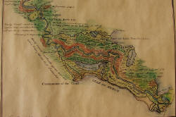
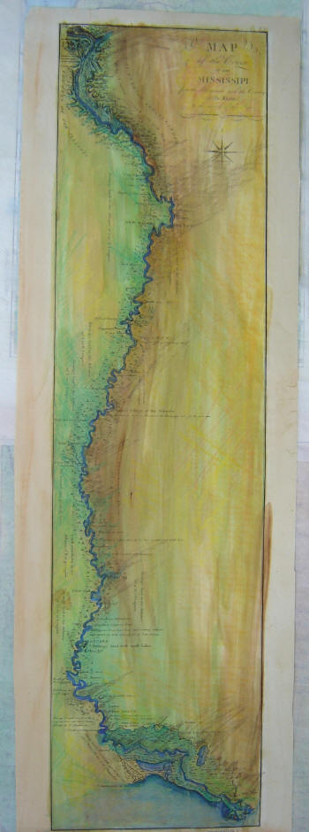
(Detail) Map of
the Course of the Mississippi River
Limited Edition Gift Print.
Map of the Course of the
Mississippi River from the Missouri and the Country of the
Illinois to the Mouths of the Lower River
1796
by George Collot
Original Hand-Colored
painting of this historic map reproduction
Map size 10" x 36"
$656
1858
Plantation Map (2 in stock) Hand-Painted in exquisite Detail!
Antiqued,
hand-painted reproduction of the PLANTATION MAP, 1858, South
from Natchez, Mississippi, including parts of
Arkansas, and Louisiana.
Individual plantations are
clearly labeled.
Your
Ivory map is beautiful!! He will love it! Thanks so much!"
~ Seattle
36" x 57"
"
Questions? Please
call us at 888-255-7726 (days only, please!) or email anytime:
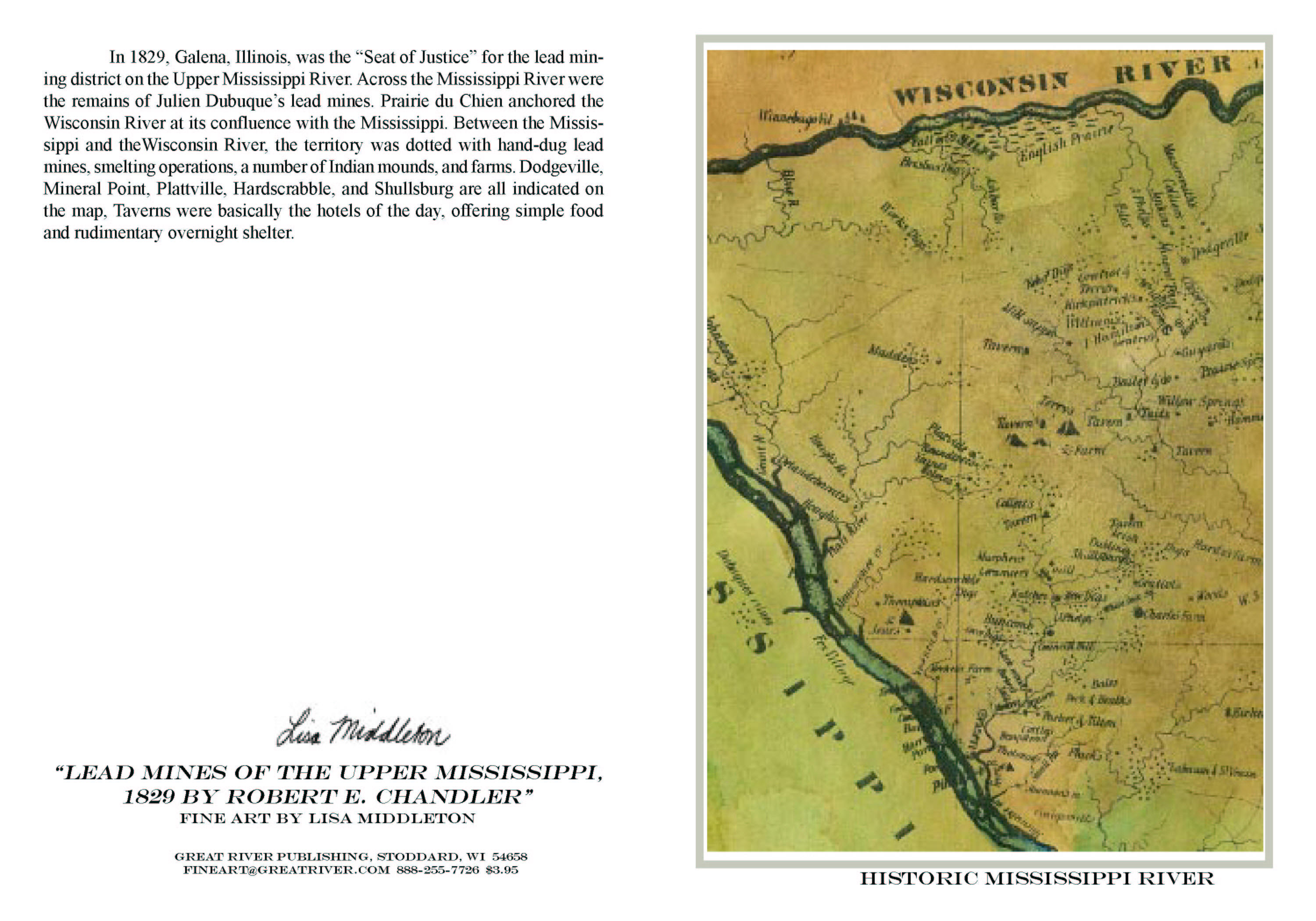
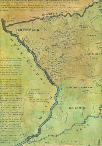
Crawford
County, Wisconsin River to the Rock River in Illinois
5x7" photo quality note cards are available
for ALL historic maps. $3.95 ea
Portion of the Crawford
County Lead Mines bounded by the Wisconsin River to the North
and the Mississippi River to the West. Includes Mineral Point,
Dodgeville to the East. Reproduction is crystal clear.
Hand-colored, $600.00
1887
Ribbon Map by Willard Glazier
Hand
Painted Collector Edition
This reproduction of a
rare Mississippi River "ribbon map" was drawn by
Captain Willard Glazier to "prove" his premise that
the True Source of the Mississippi was Lake Glazier
rather than Lake Itasca. Looking for modern day
towns on an old map? Many modern-day towns are
included in this. It also contains many towns noted no
longer appear on maps, like Waterproof...which wasn't!
Each ribbon map in this edition is delicately
and individually
hand-painted in
skillfully blended watercolor earth tones.
Available in
two sizes.
Hand-Painted Father of Waters
4" x 45" $300
Map shown below
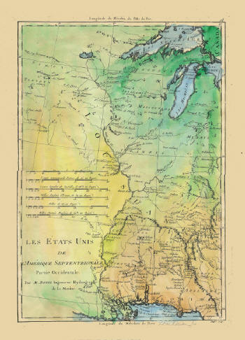
L'Amerique
Septentrionale
Partie Occidentale
Par (by) M. BONNE
Ingenieur Hydrographe de la Marine.
LES ETATS UNIS
(The United States)
All French, good detail from
Lac Superieur to the mouths of the Mississippi. To south,
it shows Ft. de la Pointe Coupee, R. Rouge, Ft. des
Natches, Ft. St. Pierre and mentions Ft. Rosalie without
the usual annotation that the Fort was destroyed (seen in
our maps dated 1756 or later).
In the north it shows a very
large Lac Rouge, Saute St. Antoine (St. Anthony Falls),
Fort St. Nicolas near the Ouisconsing (Wisconsin) R. and etc.
Good detail on Fort S.
Philippe, Cahokias, and several lead mines in the Ste.
Genevieve area. Good detail on the Ohio River and it's
tributaries. Good detail of the Apalachian Mountains,
Georgie, Cherokee country, etc.
More detail East of the
Mississippi than West (although there is good detail for
inland Minnesota). Unlike any other map, it shows the
Mississippi going towards inland Minnesota and notes that
the source is UNKNOWN.
The maps are beautifully
hand-tinted in color and in brown tones. The print on the
smaller size is readable, but the larger size is much
easier to read.
For detail of the upper
River, Minnesota, and east to Michigan and the Appalachian
mountains, these maps are my favorites.
Beautifully Hand Colored Reproduction of the 1698 Italian "GULFO DEL MESSICO"
Price: $256.00
From the Arkansas River to the Gulf of Mexico (includes the
Arkansas Post) and EAST to the northern coast of Florida. This
ITALIAN map is one of our most detailed and most beautiful maps.
Email us!
or Phone 888-255-7726 to ORDER
Carte de La Louisianne - French Map of the Missouri River
1757
from the Appalachians to the Rockies, North to St. Paul, the
entire Mississippi. Notes French colonies, Indian nations and
towns, Mines, the River St. Louis (Mississippi River) and
adjacent rivers. From the "Saute de St. Antoine" (Minneapolis) to the
Gulf. Very detailed for much of the Missouri River and western
regions. Mouth of the Mississippi is marked as "unknown".
Hand painted $226.00
Map size 13"x18"
Email us!
or Phone 888-255-7726 to ORDER
Lt.
Ross Map of the Course of the Mississippi from Fort du Chartres
in opposite the Missouri River to the Gulf.
Prepared in 1765. (portion shown)
44.5 x 17 inches Hand-colored $456
14x36" Hand Colored $280
Lieutenant Ross' large scale map
of the Mississippi is the largest format map of the Mississippi
during the 18th Century, and the most detailed British Military
Survey of the River. The map is based upon D'Anville's large map
of 1746 and his Carte de la Louisiane published in 1752. Shows
Fort Chartes in the north, and Fort Kaskaskia. Adds substantial
detail for southern portions of the map, including Pointe Coupee
and Fort Rosalie.
Email us!
or Phone 888-255-7726 to ORDER
Mississippi
River HEADWATERS 1887
Willard Glazier Limited Edition Color Print
Map size
16"x11" $24.95
Original, signed, hand-painted version of this 1887 map is
also available.
Includes Glazier's exact canoe route
and dates from his journey through the headwaters of the
Mississippi River to the lake he called Lake Glazier.
Or Phone 888-255-7726 to ORDER
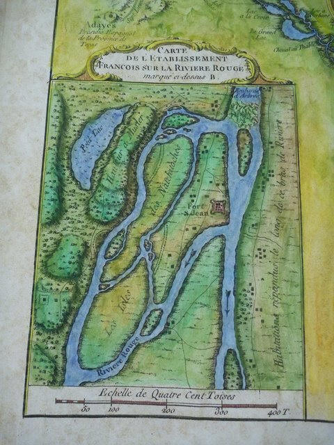
Suite
du Cours du
Fleuve St. Louis (Mississippi River)
by Jacques Nicolas Bellin (1703-1772), published in Paris, 1764
Newly Arrived!
From the Iberville to the Yazoo River. Fort Rosalie
(Natchez) is shown. Also Fort de la Pointe Coupee.
A portion of the Red River is detailed as well as an inset map
of French settlements near the Natchitoches and
historic Fort St. Jean. Click link to see details of this
map!
Bellin is one of the most proficient French cartographers
of the mid-eighteenth century. Appointed the first "Ingenieur
Hydrographe de la Marine."
We also have just TWO ARTIST's PROOFS Available! Beautiful print
reproductions in full size...
Note on pricing: If you have been visiting this site, you will
notice a price increase on all the hand-painted historic map
reproductions. As we compete with art galleries to carry the
maps, our costs are rising. Additionally, we have upgraded
the weight and archival properties of both the hand painted maps
and our NEW option of an individually hand-printed ARTIST's
PROOF.
Yes!
We do
paint privately owned maps.. we will produce a high resolution
scan to the size you require. Phone or email us with your query.
Email us!
or Phone 888-255-7726 to ORDER
Or Return to the Mississippi River Home Page,
www.greatriver.com
We are in the process of adding the rest of our
maps to this shopping cart... To ORDER any of the above maps,
just call us at 888-255-7726!
Please check back!!
Meanwhile we recommend to you any of the following great
Mississippi River art products!
Unique
real-photo NOTE CARDS of hand painted antiqued maps. 5x7 size,
individually packaged with envelope and clear acetate. Set
covers stretches of the entire Mississippi River. Extremely
limited edition!
Ask us how to put your
favorite bit of the river on a custom note card!
Frameable
Steamboat Sketches by Neal Fink
Framable prints of 20+ historic riverboats.
Click photo, left, to see our entire selection of prints.
Note which specific boat prints you wish to purchase in the
comment box of the online order form when you click the
purchase button below..
For More on
Steamboat History we recommend
Come
Hell or High Water
by Michael Gillespie
A
Lively History of Steamboating... with a delightful and
informative anthology of accounts from steamboat passengers,
crews and journalists of the 19th century. Personal accounts of
all aspects of steamboat travel from the development and
construction of vessels, to steamboat races, accidents and the
pleasures of Mississippi & Ohio river travel.
Come Hell or High Water
Price: $19.95
Subscribe to Greatriver.com
If
you have enjoyed visiting our award-winning Mississippi
River Home Page, consider subscribing TODAY.
Voluntary
user donations are VITAL to keeping
greatriver.com on line!
Your
subscription entitles you to a unique @GREATRIVER.COM
Email Address!! Ideal for river businesses and buffs.
What's new this month...!
Eagles reign on
the Upper Mississippi River while in the south. The Delta
Region promises cooler temps, Spring Pilgrimage tours, and less humidity than is
seen during the summer. Vol 4 of
Discover! America's Great River Road provides all the
insights you need to explore the Mississippi River Delta.


 Map of the Course of the
Mississippi River from the Missouri and the Country of the
Illinois to the Mouths of the Lower River
Map of the Course of the
Mississippi River from the Missouri and the Country of the
Illinois to the Mouths of the Lower River


 1757
from the Appalachians to the Rockies, North to St. Paul, the
entire Mississippi. Notes French colonies, Indian nations and
towns, Mines, the River St. Louis (Mississippi River) and
adjacent rivers. From the "Saute de St. Antoine" (Minneapolis) to the
Gulf. Very detailed for much of the Missouri River and western
regions. Mouth of the Mississippi is marked as "unknown".
1757
from the Appalachians to the Rockies, North to St. Paul, the
entire Mississippi. Notes French colonies, Indian nations and
towns, Mines, the River St. Louis (Mississippi River) and
adjacent rivers. From the "Saute de St. Antoine" (Minneapolis) to the
Gulf. Very detailed for much of the Missouri River and western
regions. Mouth of the Mississippi is marked as "unknown". 


 Come
Hell or High Water
Come
Hell or High Water
 in the south. The Delta
Region promises cooler temps, Spring Pilgrimage tours, and less humidity than is
seen during the summer. Vol 4 of
Discover! America's Great River Road provides all the
insights you need to explore the Mississippi River Delta.
in the south. The Delta
Region promises cooler temps, Spring Pilgrimage tours, and less humidity than is
seen during the summer. Vol 4 of
Discover! America's Great River Road provides all the
insights you need to explore the Mississippi River Delta.