THE OHIO RIVER, from the series, TRIBUTARIES OF THE MISSISSIPPI RIVER
c Pat Middleton, greatriver.com
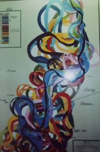
Numerous overnight cruising paddleboats are once more cruising the Ohio River! Our single most popular map of the Mississippi is a Ribbon from 1887 designating all the towns along the river… and map artist, Lisa Middleton, now makes her hand-painted RIBBON MAP of the OHIO RIVER available to all!
Click map image below to visit www.greatriverarts.com>Shop>Ohio River

Ohio River provided by www.greatriverarts.com
The Ohio River begins in Pittsburgh, Pennsylvania at the confluence of the Allegheny River and the Monongahela River, extending roughly 900 miles downstream and ending in Cairo, Illinois. Throughout time, the Ohio River has been called many names by different civilizations. The Shawnees called it Spaylaywitheepi, the Miami tribes, the Causisseppione, the Delawares, Kitonosipi, and the French, La Belle Riviére, meaning “the beautiful river.” It was called the “River Jordan” by slaves escaping to freedom in the North using the Underground Railroad in early 1800s. The name Ohio comes from the Iroquois word, “O-Y-O,” meaning “the great river”.
As early as 700 B.C., the first humans on the river were the Adena culture, followed by the Hopewell culture around 400 B.C. The Adena culture made their mark on the land erecting unique conical burial mounds along the river’s course and its tributaries. The Hopewells had larger earthen mounds in the same area as the Adenas. Later, the Shawnees, Cherokees, Iroquois, and Miamis, used the Ohio River at different periods as a site to launch violent raids, dubbing the river the “River of Blood” by the tribes.
In the 1670s, the French established trading posts along the Ohio River tributaries, including the Beaver, Wabash, and the Scioto Rivers — but the Ohio River remained unexplored. The first European to see the Ohio River was Frenchman Rene Robert Cavelier Sieur de La Salle in 1669. By the 1880s, the Ohio River became an important commercial route, and also a transportation route for families who migrated to establish settlement in the West.
Today, the Ohio River continues to serve as a major artery for transporting coal, grain, steel, and manufactured articles. The Ohio River is still important to communities, providing drinking water and as well as boating, fishing, swimming, and other water sports.
Other available fine art Ribbon Maps include The Mississippi River and the Missouri River. Please click links to view maps and Tributary information!
We also have two FRENCH maps available with details of the OHIO RIVER. Both Maps are also Rich in Mississippi River info. (To study maps at greatriverarts.com use the Hi Rez magnifying glass that pops up when you hold your cursor over an image.)
Les Etats Unis late 16th Century

Carte de La Louisiane. Early 16th Century
Return to the MISSISSIPPI RIVER HOME PAGE at greatriver.com


 e Missouri River, flowing east and then south for thousands of miles is North America’s longest river. It is a gem of natural resources and a vital transportation pathway. Nicknamed the “Big Muddy” and “Dark River” because of its silt material, the river begins at the confluence of the Madison and Jefferson Rivers in the Rocky Mountains of western Montana. The river flows across eastern Montana, then continues through the center of the Dakotas on its southern trek, before becoming the state line between Nebraska and Iowa, then dividing Kansas from Missouri. The Missouri travels east again across the upper part of the state that carries its name before entering the Mississippi River just north of St. Louis.The Missouri River valley was the home of several Native American tribes around 1500, including the Mandan, Arikara, Missouria, Lakota, Hidatsa, and Otoe, among others. French explorers Louis Jolliet and Jacques Marquette, in 1673, were the first Europeans to see the Missouri River. However, it was the Lewis and Clark Expedition (1804-1806) that produced the most promise and paved the way for the Missouri River to define the American Frontier. The discovery of a navigable Missouri River route made possible the growth of the fur trade in the early 1800s. Fur trappers in the upper Missouri River basin bartered iron, brass, knife, blankets, cloth, metal, firearms, metal containers, and even alcohol with Indians, for beaver pelts and the hides of bison and buffalo.The function of the Missouri River has changed over time, and today, tourism and recreation are the two key features of the river. Kayaking, canoeing, bird watching, camping, fishing, and hiking are some of the activities that can be enjoyed on or along the river. The Lewis and Clark National Historic Trail, which crosses eleven U.S. states and retraces the course of Louis and Clark Expedition, is a feature attraction along the Missouri River. Still, the Missouri River flows through or past many National Historic Landmarks including the Big Hidatsa Village Site in North Dakota, and Montana’s Fort Benton, among others. There is plenty to explore and enjoy!


